Carl's Big Adventure
Alright... you may want to grab a chair before diving into what could be
Cold Lampin's longest entry yet...
In May 2006 (over a year ago?!?) I had a two week vacation, so I hopped
in my trusty Honda Civic (thanks Uncle Doug) and set forth on an epic
road trip.

Hear's my attempt at a self-portrait while speeding down the penninsula
on I-280. I almost crashed into a median trying to get the right picture...

Anyhoodle, I am a HUGE fan of the solo road trip. When you go by yourself
you can pretty much do whatever you want. I've had weekend roadtrips
where I planned to do something specific, but then ended up somewhere
completely different just because that's where the wind blew me. The fewer
hotel/campsite reservations, the better. For this trip, I basically set out
heading south and knew that I had to be in San Diego in 7days to meet
up with Z-Diddy and Doug "The Jug" Newton. My only other criteria were
that I wanted to see Big Sur and Joshua Tree National park. The red line on
the map above marks my eventual route, which ended up being a ginormous
figure-eight covering a big chunk of California. Looking at the route, I realize
I must have done a lot of driving, but it seemed like I was hiking/camping
a whole lot more. I find it pretty easy to get in the zone while driving solo,
and tend to chew up the miles.

So, I headed down the peninsula and went over the Santa Cruz mountains,
past Monterey, and on to Big Sur. It's an isolated 70mile stretch of the
central Californian coast that runs from the Monterey peninsula to San Luis
Obispo. Highway 1 winds it's way down this stretch, clinging to the cliffs above
the Pacific, in what some author whom I can't remember (Henry Miller?) called
"The greatest meeting between land and sea." I pretty much have to agree.
It definitely makes my Top 3 must-see list for anyone visiting California
(along with San Francisco and Yosemite.)

I immediately scored a sweet creekside campsite amongst the redwoods
in Pfieffer-Big Sur State Park (which was almost deserted despite being
the week before memorial day,) and set up my trusty tent.
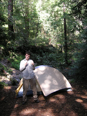
Here's an obligatory Cold Lampin' shot (I've got to live up to this blog's
reputation.) West-coast Represent!!

After setting up camp, I did a short little hike in the park to Pfieffer Falls
and the Big Sure River Valley overlook.

It started out along a little creek that made it way upward through a
canyon full of redwoods...

A few miles in the trail spurred off to the falls...

Purty...

The trail then continued up and up until you reached the overlook of the
Big Sur River valley.

The river runs from the coastal mountain range straight to the ocean.

I was a little over-heated from the hike, so I climbed a tree and sat in the shade
to cool off, and took a self-portrait...

... and tried out my camera's macro feature on some cool lichens...

...and moss.

After taking a breather for awhile, I hiked back down through the redwoods back
to my campsite, and then hopped in the car to drive down the coast a bit.

This is the typical view... I almost drove off a cliff several times while trying
to oogle the scenery. I guess that is one disadvantage of the solo roadtrip.

I ended up pulling off the side of the road and finding a good rock to sit on
and watch the ocean. Withing about 5minutes of sitting down, I saw a bunch of
these beautiful purple lupines, a bunch of sea-lions basking on the rocks below,
and a grey whale swam by right below me... Crazy.

Purty...

I sat on my rock for a few hours, took a cat nap, perused my guidebooks
to make plans for the next day, and then took in a beautiful sunset.

Purty...

Then it was back to my humble abode for the night.

I cooked breakfast the next morning (Hello delicious eggs-in-a-raft, Boy Scout camp
style) and then hopped in the car. The beauty of Big Sur further blew my tiny
little mind with the morning sea fog still abutting the coastal cliffs.

The pictures don't do it justice. It was way too cool...

Purty... (I may be reaching a Cold Lampin' record for "Purty" superlatives in
one post.)

I drove down Highway 1 for a while, and stopped at Julia Pfieffer-Burns
State Park. There I did the Ewoldson Trail hike which again started out following
a small creek up a redwood canyon.

There was a little spur trail off to a waterfall, so I took it, and when I arrived
I saw a man in his late 60's who was trying to help a woman in her late-60's
who had fallen in the middle of the creek. I ran up to help and ended up wading
into the river, picking the woman up, and carrying her to the bank. It turns out
she (her name was Shea) had had a hip replacement the previous fall, and after months of rehabilitation was out with her husband on her inaugural hike with the new hardware.
She had been crossing the creek on a log when her hip gave out, causing her to fall into the
water. She was unable to get up herself, and her husband had been trying to fish her
for about 10minutes before i arrived. When I got her to the bank I could tell that her
hip was definitely dislocated and I her husband and I weren't going to be able to
get her back down the trail alone. I left her my sweatshirt and jacket and ran
back to the trailhead and used the payphone to call the EMT's. While waiting for
them to arrive, I grabbed a bunch of warm clothes and my "space blanket" from
my car's emergency kit (props to Big Daddy for making each of his children a
well stocked car kit) and headed back up the trail. I dropped the warm clothes off
and then head back down to guide the EMT's up. I even helped out and started the
IV for them while they drew up the morphine. Anyway, the mountain rescue crew arrived and they helped the woman down on a big sled. Shea and her husband were super nice,
and a month later when they mailed me back my clothes I had given her to stay warm,
they also included a package of chocolate-chip cookies and a nice messenger bag.
They emailed me a few months later and explained that the Shea's artificial hip had popped out of it's socket, causing her to fall. But they had replaced it, and after a few more months
of rehab, she and her husband were planning a hiking trip in Alaska (although they
were going to avoid any log river crossings.

Here's the mountain rescue crew carrying Shea out on the sled.

Picking their way down the trail...

At the spur trail I continued up through the canyon while the rescue crew
and Shea headed out to civilization.

After all that excitement I continued to climb, and once I got above the
redwoods, views towards the ocean started opening up.

The layer of fog that had been hugging the coast earlier in the morning
had burned off...

...or almost burned off...

...openining up great views of the coast and water.

...at the top of the trail I took a break for lunch and a couple of self portraits.

Carl Nosek Glamour Photo #978

California's state flower: the Golden Poppy.

Purty...

After breaking for lunch, I hoofed it back down the trail and then crossed under
the road to get a peak at McWay's Falls. Pretty much one of the more picturesque
spots you'll ever find.
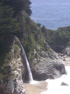
That's REAL nice...

...REAL nice.

Carl Nosek Glamour Photo #980 (#979 was taken in the port-a-potty at
the trailhead and is NSFW)

More Big Sur vistas...
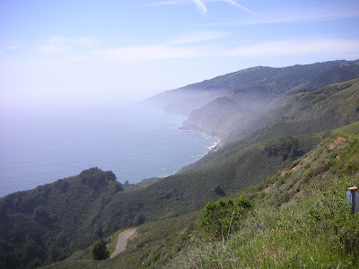
I hopped back in the car and headed south on Highway 1 until I reached
Nacimiento-Fergusson road which pretty much heads straight up into
the mountains (you can see a little stretch of the road below me in the picture.)

There were great views of the ocean as you headed up...

Carl Nosek Glamour Photo #981

The road is very narrow and winds it's way through the Santa Lucia mountains.
Eventually it opens up to a wide valley which is actually the site of one of my
favorite books, Steinbeck's "To a God Unknown." This is the valley he used as
the inspiration for the location of Joseph Wayne's farm. Everybody should read
this book. It is very dark, and full of allusions to the great greek myths, ancient
pagan beliefs, and christianity. As can be expected the way these three butt
heads is a major theme. Highly recommended.
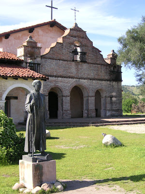
The small town of Jolon (in the book it's called Neustra Senora) still has the old
Franciscan Mission San Antonio de Padua (part of the Junipero Serra chain
of missions.)

I poked around for awhile, and then...

...headed back over the mountains to the coast...

...where the fog was filtering in.

I pulled over and found another rock to sit on to take in another beautiful
sunset...

The next morning I broke camp, loaded up the car, and headed south
on Highway 1. I stopped midmorning at Limekiln State Park, and did
a quick hike to check out some falls and...

...the eponymous Limekilns.

In these giant stoves, lime was cooked out of the local rock to be used in
building projects.

The fog was in thick this day, creating a verdant landscape. Because the views
were obscured I headed out of Big Sur, drove across the central valley, and...

...within a few hours was in the middle of the desert. That's the crazy thing
about California. You can pretty easily take a picture next to a coastal stream
surrounded by moss and redwoods, and then a few hours later be in the middle
of a desert or way up in the mountains. I still think Wisco is the best state in the
Union, but it is hard to beat California for shear geographic variety.

Here I am with an incredulous look on my face, thinking "I am in the middle
of f*(%!#@ nowhere!"

... seriously. Nothing around for miles except for the occasional passing car.

I passed through Barstow (pretty much an oasis of motels and gas stations
on the edge of the desert, and the last real outpost before you hit Vegas) and
spent the night in an air-conditioned motel. The next morning I got up early
and drove to the middle of nowhere and entered Mojave National Preserve.

I did a hike in the Kelso Sand Dunes which was only about 45minutes long...

Despite carrying 2 liters of water...

...by the time I slogged my way to the top (hiking in deep sand is rough going)...

...I didn't know if I was going to make it back to my car.

The views from the top of the dunes, however, were worth skirting death for.

Even now I get thirsty when I look at these pictures.

After barely surviving the death march back to my car, I went and cooled
off in the air-conditioned splendor of the preserve's visitor station, and then
set up my tent at one of the campsites. I had a delicious dinner of mac-n-cheese
w/ hot dogs, and then cracked open the 6-pack of Anchor Steam that I had
squirreled away in it's own personal cooler of ice (priorities people... priorities.)
The night was super-clear, and I ended up sleeping outside my tent and finishing
off the beers while gazing up at the stars. (In my defense, I had sweated out about
half my bodyweight during the day's hike, so six beers is not that big of an accomplishment.)

The next morning I got up early and took off in my little car (which looks
lonely in this picture.) I headed south, driving on Route 66 for a little ways,
and passed through some of the loneliest towns in America, Amboy and Essex.

After a few hours of lonely driving, I arrived at Joshua Tree National Park.
For those who don't know, the weirdly shaped tree in this picture is a Joshua
Tree (named by the Morman's who thought it looked like Joshua raising his
hands to the sky.) And, yes... I did have the U2 album on hand to play as I
entered the park.

I scored a great campsite in the Ryan campground...

..and set up my tent (on a pretty severe slant I noticed when looking at this
picture!?!)

I then got in my car and drove around the park for awhile.

Joshua Tree National Park is a high desert, and the elevation makes it much
cooler. My campsite was at about 4,800 feet where it got cold at night.

The forests of Joshua Trees were pretty cool. Named Yucca brevifolia,
they are a monocotyledonous tree native to southwestern North America,
in the states of California, Arizona, Utah and Nevada. They only grow between
2,000-6,000 feet of elevation, and only on flat or gently sloping surfaces...
...Damn...
....
... Cold Lampin' is dropping some serious knowledge.
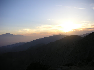
I drove out to Keys View to watch the sun set over the Coachella
Valley.

Nice...

Carl Nosek Glamour Shot #986 (I apparently took several glamour
shots after downing the six-pack the night before, none of which
really turned out...)

Sweet...

The next morning I got up early and did a hike to the top of Ryan
Mountain before it got too hot.

These pictures don't give the proper sense of scale of how huge
the rock formations are...

The day was clear enough to see all the way to Mount San Jacinto,
which looms above Palm Springs.

A closer view of it's snow-capped peak (10,679ft.)

More views...

Later I took a hike through one of the densest collections of Joshua
Trees.

Cool...

Here is what I look like after 3 days of camping and hiking in the
desert.

I drove out through the southern part of the park, and dropped
elevation significantly from the Mojave high desert to the lower,
and much hotter Colorado desert.

The southern half of the park is not as interesting (too low of
elevation for the Joshua Trees, and none of the interesting boulder
fields.) I did make a stop at the Cholla Cactus garden.

These extremely prickly cacti are called "jumping" cacti because
they seem to leap out at you and poke you.

Those needles hurt...

They were just in bloom when I passed through...

Ooohhh.... macro....

The ocotillo trees were also in bloom.

Pretty...
Anyway, I headed south through the desert and ended up in Anza-
Borrego Desert State Park. I camped for one night there and took
a hike in one of the plam oases, but I don't seem to have any pictures
of this leg of the trip.
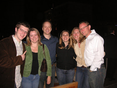
Next thing I knew, I was in San Diego, staying with Mike and
Dana and meeting up with...

Doug "the Jug" Newton who was in town for a conference.

Two of his fellow psychiatry residents were in attendence (and
quickly learned how to Cold Lamp with a fierceness...)

...as was Doug's wife Carrie, who is at this writing currently with child!
Congrats! He/she will obviously be in good hands with parents who
now how to represent like this...

The lovely Dana gives me the get-a-load-of-this-fuggin-guy
finger (and I naturally return the favor.)

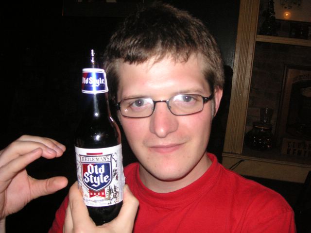
This was my cover shot for the most recent issue of GQ.

A master practices his craft...

You can't stop us... you can only hope to contain us.

Mike... I'm sorry that I have this foxy picture of your wife, and yet
fail to have any pictures of you. Was it because you were taking
all the pictures?

The next day we bummed around San Diego and hit the beach.

This picture of Doug is illegal in 37 states. To hott for TV.

The surf was not very good when we were in San Diego, but at one of
the beachside bars they had this wave machine which made a perpetual
tube for people to surf in. It was pretty sweet.
Anyhoodle, that's the trip. From coastal redwoods and wave crashed cliffs
to desert vistas and cacti to urban cities and beach culture... California in 10days.


...openining up great views of the coast and water.

...at the top of the trail I took a break for lunch and a couple of self portraits.

Carl Nosek Glamour Photo #978

California's state flower: the Golden Poppy.

Purty...

After breaking for lunch, I hoofed it back down the trail and then crossed under
the road to get a peak at McWay's Falls. Pretty much one of the more picturesque
spots you'll ever find.

That's REAL nice...

...REAL nice.

Carl Nosek Glamour Photo #980 (#979 was taken in the port-a-potty at
the trailhead and is NSFW)

More Big Sur vistas...

I hopped back in the car and headed south on Highway 1 until I reached
Nacimiento-Fergusson road which pretty much heads straight up into
the mountains (you can see a little stretch of the road below me in the picture.)

There were great views of the ocean as you headed up...

Carl Nosek Glamour Photo #981

The road is very narrow and winds it's way through the Santa Lucia mountains.
Eventually it opens up to a wide valley which is actually the site of one of my
favorite books, Steinbeck's "To a God Unknown." This is the valley he used as
the inspiration for the location of Joseph Wayne's farm. Everybody should read
this book. It is very dark, and full of allusions to the great greek myths, ancient
pagan beliefs, and christianity. As can be expected the way these three butt
heads is a major theme. Highly recommended.

The small town of Jolon (in the book it's called Neustra Senora) still has the old
Franciscan Mission San Antonio de Padua (part of the Junipero Serra chain
of missions.)

I poked around for awhile, and then...

...headed back over the mountains to the coast...

...where the fog was filtering in.

I pulled over and found another rock to sit on to take in another beautiful
sunset...

The next morning I broke camp, loaded up the car, and headed south
on Highway 1. I stopped midmorning at Limekiln State Park, and did
a quick hike to check out some falls and...

...the eponymous Limekilns.

In these giant stoves, lime was cooked out of the local rock to be used in
building projects.

The fog was in thick this day, creating a verdant landscape. Because the views
were obscured I headed out of Big Sur, drove across the central valley, and...

...within a few hours was in the middle of the desert. That's the crazy thing
about California. You can pretty easily take a picture next to a coastal stream
surrounded by moss and redwoods, and then a few hours later be in the middle
of a desert or way up in the mountains. I still think Wisco is the best state in the
Union, but it is hard to beat California for shear geographic variety.

Here I am with an incredulous look on my face, thinking "I am in the middle
of f*(%!#@ nowhere!"

... seriously. Nothing around for miles except for the occasional passing car.

I passed through Barstow (pretty much an oasis of motels and gas stations
on the edge of the desert, and the last real outpost before you hit Vegas) and
spent the night in an air-conditioned motel. The next morning I got up early
and drove to the middle of nowhere and entered Mojave National Preserve.

I did a hike in the Kelso Sand Dunes which was only about 45minutes long...

Despite carrying 2 liters of water...

...by the time I slogged my way to the top (hiking in deep sand is rough going)...

...I didn't know if I was going to make it back to my car.

The views from the top of the dunes, however, were worth skirting death for.

Even now I get thirsty when I look at these pictures.

After barely surviving the death march back to my car, I went and cooled
off in the air-conditioned splendor of the preserve's visitor station, and then
set up my tent at one of the campsites. I had a delicious dinner of mac-n-cheese
w/ hot dogs, and then cracked open the 6-pack of Anchor Steam that I had
squirreled away in it's own personal cooler of ice (priorities people... priorities.)
The night was super-clear, and I ended up sleeping outside my tent and finishing
off the beers while gazing up at the stars. (In my defense, I had sweated out about
half my bodyweight during the day's hike, so six beers is not that big of an accomplishment.)

The next morning I got up early and took off in my little car (which looks
lonely in this picture.) I headed south, driving on Route 66 for a little ways,
and passed through some of the loneliest towns in America, Amboy and Essex.

After a few hours of lonely driving, I arrived at Joshua Tree National Park.
For those who don't know, the weirdly shaped tree in this picture is a Joshua
Tree (named by the Morman's who thought it looked like Joshua raising his
hands to the sky.) And, yes... I did have the U2 album on hand to play as I
entered the park.

I scored a great campsite in the Ryan campground...

..and set up my tent (on a pretty severe slant I noticed when looking at this
picture!?!)

I then got in my car and drove around the park for awhile.

Joshua Tree National Park is a high desert, and the elevation makes it much
cooler. My campsite was at about 4,800 feet where it got cold at night.

The forests of Joshua Trees were pretty cool. Named Yucca brevifolia,
they are a monocotyledonous tree native to southwestern North America,
in the states of California, Arizona, Utah and Nevada. They only grow between
2,000-6,000 feet of elevation, and only on flat or gently sloping surfaces...
...Damn...
....
... Cold Lampin' is dropping some serious knowledge.

I drove out to Keys View to watch the sun set over the Coachella
Valley.

Nice...

Carl Nosek Glamour Shot #986 (I apparently took several glamour
shots after downing the six-pack the night before, none of which
really turned out...)

Sweet...

The next morning I got up early and did a hike to the top of Ryan
Mountain before it got too hot.

These pictures don't give the proper sense of scale of how huge
the rock formations are...

The day was clear enough to see all the way to Mount San Jacinto,
which looms above Palm Springs.

A closer view of it's snow-capped peak (10,679ft.)

More views...

Later I took a hike through one of the densest collections of Joshua
Trees.

Cool...

Here is what I look like after 3 days of camping and hiking in the
desert.

I drove out through the southern part of the park, and dropped
elevation significantly from the Mojave high desert to the lower,
and much hotter Colorado desert.

The southern half of the park is not as interesting (too low of
elevation for the Joshua Trees, and none of the interesting boulder
fields.) I did make a stop at the Cholla Cactus garden.

These extremely prickly cacti are called "jumping" cacti because
they seem to leap out at you and poke you.

Those needles hurt...

They were just in bloom when I passed through...

Ooohhh.... macro....

The ocotillo trees were also in bloom.

Pretty...
Anyway, I headed south through the desert and ended up in Anza-
Borrego Desert State Park. I camped for one night there and took
a hike in one of the plam oases, but I don't seem to have any pictures
of this leg of the trip.

Next thing I knew, I was in San Diego, staying with Mike and
Dana and meeting up with...

Doug "the Jug" Newton who was in town for a conference.

Two of his fellow psychiatry residents were in attendence (and
quickly learned how to Cold Lamp with a fierceness...)

...as was Doug's wife Carrie, who is at this writing currently with child!
Congrats! He/she will obviously be in good hands with parents who
now how to represent like this...

The lovely Dana gives me the get-a-load-of-this-fuggin-guy
finger (and I naturally return the favor.)

This was my cover shot for the most recent issue of GQ.

A master practices his craft...

You can't stop us... you can only hope to contain us.

Mike... I'm sorry that I have this foxy picture of your wife, and yet
fail to have any pictures of you. Was it because you were taking
all the pictures?

The next day we bummed around San Diego and hit the beach.

This picture of Doug is illegal in 37 states. To hott for TV.

The surf was not very good when we were in San Diego, but at one of
the beachside bars they had this wave machine which made a perpetual
tube for people to surf in. It was pretty sweet.
Anyhoodle, that's the trip. From coastal redwoods and wave crashed cliffs
to desert vistas and cacti to urban cities and beach culture... California in 10days.

posted by Carl Nosek at 7:21 PM
![]()

3 Comments:
An outstanding travelogue.
I really enjoyed reading this! Kind of felt like I was intruding, but I kept reading. : )
HI CARL,
I TOOK UP SOLO CAMPING LAST SPRING, MAKING SHORT TRIPS FROM PASADENA, CA. I GO TO THE SIERRAS OR THE COAST, AND HAVE BEEN WONDERING ABOUT THE DESERT FOR THIS WINTER. YOUR PHOTOS OF MOJAVE N.P. ARE GREAT; I THINK I'LL TRY IT. THANKS FOR SHARING.
Post a Comment
<< Home